Midway South Special Area Study
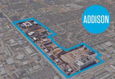
At its August 9, 2022 meeting, the City Council adopted the Midway South Special Area Study, a long-range planning policy guiding future development and the provision of infrastructure and social amenities within a 79+/- acre area bounded by Belt Line Road to the north, Hornet Road to the south, Midway Road to the east, and existing residential neighborhoods to the west. The Midway South is the expansion of the Sam’s Club Special Area Study which started in 2014 in accordance with policy direction provided within the 2013 Comprehensive Plan, and included an area of land generally running from the former Sam’s Club site south along the Midway Corridor, including the Midway Square Shopping Center and Office in the Park. At the conclusion of that process in 2015, the City Council only provided direction on the portion of the study area that was the former Sam's Club property. The vision for the other areas within the study area was never finalized. In April 2021, the City Council approved a professional services agreement for a planning consultant and appointed a project advisory committee to complete the study. With the establishment of a 17-member project advisory committee for this re-initiated special project, the City Council directed staff to expand the study area further south to include commercial properties between Office in the Park and the Greenhill School campus.
After multiple meetings with the advisory committee and public input sessions, a draft plan was developed and made available for public review and feedback beginning on June 17, 2022. At its August 9, 2022 meeting, the Council adopted the plan and also renamed it to be "Midway South" in order to define the study by its geographic location rather than as a former retailer.

